TS
pengembara2015
teropong untuk penerbangan malam militer (TNI dah punya belum ?)

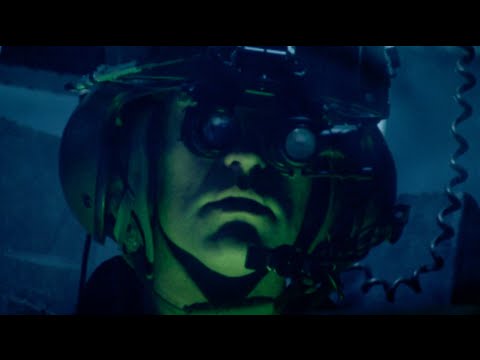
Elbit Systems introduces BrightNite a solution that enables utility helicopters to successfully perform Degraded Visual Environment (DVE) missions in more than 90% of night flying situations, providing them with piloting capabilities of attack helicopters and enabling a new level of operational flight.
Lightweight, compact and cost-effective, BrightNite is a multi-spectral end to end panoramic piloting solution that delivers the essential data directly to both eyes of the pilot, enabling intuitive flight in a head-up, eyes-out orientation in pitch dark and other DVE conditions.
The unique solution is comprised of non-gimballed uncooled FLIR and highly sensitive Complementtary Metal-Oxide Semiconductor (CMOS) sensors that present an ultra-wide field of regard intuitive image to a display system which projects to the ANVIS/HUD night Helmet Mounted Display (HMD). The display is overlaid by a synthetic layer that follows the contours of the landscape and a third layer of 3D conformal symbology, which displays hazards, mission conformal symbology and tactical data. Multiple crew-members can simultaneously scan the entire field of regard, using a single sensor and the synthetic world, enabling them to fly in common Line-Of-Sight (LOS).
The new and unique BrightNite solution will be presented at the Elbit Systems’ booth (Chalet A-200) at the upcoming Paris Air Show.
BACKGROUND NOTES:
Low-flying aircraft are especially vulnerable to threats such as difficult terrain, enemy fire and the intersection of utility wires in the flight path. Sorties must often be carried out in a Degraded Visual Environment (DVE), adding to the already heavy workload and leaving flight crews to rely on NVGs to accomplish their mission. Factors limiting the pilots’ FOV include: complete darkness, poor weather conditions, brownouts, whiteouts and sandstorms.
According to the U.S. Army Aviation there is a problem with spatial disorientation while operating in degraded visual environments. Historically, approximately 20 percent of all Class A and B mishaps have been attributed directly to spatial disorientation or loss of situational awareness in DVE, but the issue remains far from solution.
Here are some recent numbers:
During fiscal 2013, two of eight Class A accidents were caused by loss of orientation in DVE; five of 18 in fiscal 2012; two of 14 in fiscal 2011; and eight of 21 in fiscal 2010. Over the past several years, the trend for losses due to DVE-related orientation miscues matches exactly the trend Army Aviation has experienced since the U.S. Army Combat Readiness/Safety Center established a consolidated accident database in 1972. Simply put, we as an institution have made no progress, either in enhanced training methods or with technical solutions, in reducing accident rates associated with this loss factor.
Source: http://www.army.mil/article/128754/A...ing_challenge/
Elbit Systems’ BrightNite overcomes these visibility limitations and greatly improves situational awareness, mission effectiveness and above all - flight safety in DVE. The system processes real-time panorama video, enhanced by a 3D conformal mission symbology concept and transmits high-resolution video to the Helmet-Mounted Display (HMD). BrightNite utilizes unified location-based information culled from a wide FOV to display crystal clear images, in zero visibility and zero latency, enabling helicopters to successfully execute missions in more than 90% of the nights.
Elbit Systems Ltd. is an international high technology company engaged in a wide range of defense, homeland security and commercial programs throughout the world. The Company, which includes Elbit Systems and its subsidiaries, operates in the areas of aerospace, land and naval systems, command, control, communications, computers, intelligence surveillance and reconnaissance, unmanned aircraft systems, advanced electro-optics, electro-optic space systems, EW suites, signal intelligence systems, data links and communications systems and radios.
sumur
mau tanya buat sesepuh formil tni dah punya alat itu belum ga yah secara tuh alat ga hanya untuk lihat kegelapan saja tapi bisa lihat nembus kabut,thx..

0
4.8K
12
Thread Digembok
Urutan
Terbaru
Terlama
Thread Digembok
Komunitas Pilihan